Finding the best hikes Big Island Hawaii has to offer can feel like planning an expedition across an entire continent. The island is massive, its terrain shifts from molten lava fields to misty fern forests in the span of a single drive, and the sheer number of trails scattered across its four corners can overwhelm even the most organized trip planner. This guide cuts through the noise. It is built for real travelers who need to know which trails are worth their limited vacation hours, what each hike actually demands in terms of fitness and logistics, and how to avoid the mistakes that turn a dream hike into a sunburned, dehydrated slog. By the end, you will know exactly which hikes match your fitness level, budget, and itinerary, with zero guesswork on fees, parking, or safety.
Table of Contents
- Why the Big Island Is Hawaii’s Ultimate Hiking Destination
- Planning Your Hiking Trip: Fees, Permits, and Safety Essentials
- The Best Hikes Big Island Hawaii Has to Offer: Our Top 10 List
- Best Hikes Big Island Hawaii by Category: Quick Reference
- Insider Tips for Hiking the Big Island in 2026
- Frequently Asked Questions About Hiking the Big Island
- Final Thoughts: Choosing the Right Hike for Your Trip
The list that follows covers 10 trails spanning Hawaii Volcanoes National Park, the Hamakua Coast, the Kona shoreline, and the remote southern tip of the island. Each entry includes mileage, difficulty, fees, and the kind of insider detail that usually only comes from trial and error. Whether you are traveling with young kids, hunting for a world-class snorkeling payoff, or chasing the surreal experience of walking inside a volcanic crater, there is a trail here for you.
Why the Big Island Is Hawaii’s Ultimate Hiking Destination
The Big Island does not do subtlety. It is the largest landmass in the Hawaiian chain, and it contains 11 of the world’s 13 climate zones within its boundaries. On a single day, you can hike through high-altitude alpine tundra on Mauna Kea, descend into a steaming volcanic crater, and finish with a coastal walk past coconut palms and black sand. No other island in Hawaii, and few places on Earth, offer that kind of ecological whiplash.
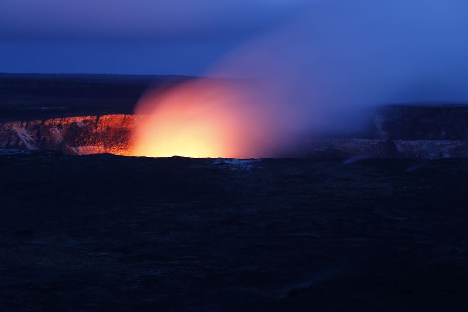
The island is also home to Kilauea, the only active volcano in Hawaii. Hiking near an active volcanic crater is a privilege that simply does not exist on Oahu, Maui, or Kauai. The landscape here is raw and visibly young: steam vents hiss along crater rims, lava tubes snake beneath the rainforest floor, and entire coastlines are still being reshaped by flows that cooled only decades ago.
Compared to the more heavily trafficked trails on Oahu or Maui, the Big Island’s hiking scene feels quieter and more rugged. You will share the trail with fewer people and more feral goats. The trade-off is distance. The island is roughly the size of Connecticut, and the trails in this guide are spread across hours of driving. Kilauea Iki sits near the town of Volcano in the southeast. Pololū Valley is at the northern tip. The Green Sand Beach is at the extreme south. This guide organizes trails by region and experience type so you can cluster your hikes and minimize windshield time.
Planning Your Hiking Trip: Fees, Permits, and Safety Essentials
Before you lace up your boots, a few practical details will save you from showing up unprepared. The most important fee to budget for is the Hawaii Volcanoes National Park entrance fee. It costs $35 per private vehicle, and that pass is valid for seven consecutive days. If you hold an America the Beautiful Interagency Pass, bring it: it covers your entry. Several trails in this guide, including Kilauea Iki, Devastation Trail, and the Thurston Lava Tube, are inside the park boundaries, so that single fee unlocks multiple hikes.
For the trails covered here, no additional hiking permits are required. Mauna Kea summit access is a different story and demands a 4WD vehicle and careful altitude acclimatization, which is why it is not included in this list. Always check the National Park Service website for temporary closures before heading out. Sections of Crater Rim Drive have closed with little notice in recent years due to volcanic activity or road damage.
Safety on the Big Island is not about dramatic wildlife encounters. It is about heat, water, and unstable ground. Flash floods are a real risk in valley trails like Pololū, especially during the wetter winter months. Volcanic gases, particularly sulfur dioxide, can concentrate near active vents on the Kilauea Iki trail and irritate respiratory conditions. Coastal trails like the Puna Trail and the Green Sand Beach route offer zero shade and relentless sun exposure. Pack at least two liters of water per person, wear reef-safe sunscreen, and carry a lightweight rain shell even if the morning sky is cloudless.
The 2026 outlook favors the dry season, which runs from May through October, for the most stable hiking conditions. Winter months, November through April, bring heavier rain to the Hilo side and can turn trails like Kaulana Manu and Pololū into mud slicks. Check the National Weather Service forecast 24 hours before any valley or coastal hike. Your gear checklist should include sturdy hiking shoes with aggressive tread: lava rock is sharp enough to shred soft-soled sneakers, and a misstep on wet basalt can end a vacation. Add a daypack, your water, high-energy snacks, and a headlamp for the lava tube.
The Best Hikes Big Island Hawaii Has to Offer: Our Top 10 List
The list below is organized by region and experience type, combining reader favorites, local recommendations, and expert picks. Each trail earns its place for a specific reason, whether it is the geological spectacle, the family accessibility, or the beach at the end.
1. Kilauea Iki Trail + Crater Rim Loop (Hawaii Volcanoes National Park)
If you only hike one trail on the Big Island, make it this one. The Kilauea Iki Trail is a 3.2-mile loop that descends through a lush rainforest into a solidified lava lake crater, crosses the crater floor, and climbs back up the opposite rim. It is repeatedly cited as the most popular hike in Hawaii Volcanoes National Park, and for good reason. The descent feels like entering another world: steam vents rise from cracks in the crater floor, and the scale of the 1959 eruption becomes viscerally clear when you are standing on the basalt it left behind.
The trail is rated moderate. The climb back up the rim is steep and gains about 400 feet of elevation, but the path is well-maintained and the footing is solid. Allow two to three hours for the full loop. Parking at the Kilauea Iki Overlook fills by 9 AM, so arrive early or park at the Visitor Center and walk the connector trail. Combine this hike with the Thurston Lava Tube, which shares the same general area, for a half-day volcano experience that hits both the crater and the subterranean world beneath it.
2. Thurston Lava Tube (Nāhuku) + Devastation Trail Combo
This pairing is the best option on the island for families with young children or anyone with mobility concerns. The Thurston Lava Tube, known in Hawaiian as Nāhuku, is a short, paved 0.5-mile walk through a 300- to 500-year-old lava cave. The tube is tall enough to walk through upright, dimly lit, and damp underfoot. Handrails line the path, and the experience of walking through a tunnel carved by molten rock is memorable for all ages.
Devastation Trail sits in the same parking area and is a 1-mile round trip, fully paved, flat, and wheelchair-accessible. It ends at the Puʻupuaʻi Overlook, which looks directly onto the cinder cone and crater formed during the 1959 Kilauea Iki eruption. The contrast between the recovering forest along the trail and the barren scape at the overlook is striking. Bring a headlamp or use your phone flashlight for the lava tube, and plan on spending about an hour total for both stops.
3. Kaulana Manu Nature Trail (Formerly Kīpuka 21) — Saddle Road
The Kaulana Manu Nature Trail is a 0.6-mile loop tucked off Saddle Road, the highway that bisects the island between Hilo and Kailua-Kona. It is one of the best effort-to-reward hikes on the island: a short, muddy walk through a native forest kīpuka, an island of mature vegetation surrounded by younger lava flows. The bird activity here is exceptional. Listen and look for the ʻIʻiwi, the scarlet honeycreeper with a curved salmon-colored bill that feeds on ʻōhiʻa blossoms.
This is a working conservation site, and the gate etiquette matters. Close every gate behind you. The fencing keeps feral pigs and goats from destroying the understory, and leaving a gate open undoes years of restoration work. The trail is muddy year-round, so wear waterproof shoes and accept that your socks will not stay clean. There are no restrooms or water sources, so pack in and pack out everything you need. The trailhead is easy to miss: look for the small sign and pull-off on the mauka side of Saddle Road.
4. Pololū Valley Lookout and Trail (Hamakua Coast)
The Pololū Valley trailhead sits at the end of Highway 270 on the island’s northern tip, and the view from the lookout alone justifies the drive. Dramatic sea cliffs plunge into the Pacific, and the valley floor spreads out below in a patchwork of green and black. The trail itself is a short but steep 0.8-mile descent to a black sand beach. The return climb is the real workout: it is short enough not to require hours of recovery, but steep enough to leave your legs shaking.
Parking at the lookout is limited to a small lot, and it fills quickly. Arrive before 10 AM or after 3 PM to avoid the worst of the tour van crowds. There are no facilities at the trailhead or the beach. Do not swim here. The currents are strong, the shore break is unpredictable, and there are no lifeguards. The trail turns dangerously slippery after rain, which is common in winter months. Check the weather and turn back if the mud makes the descent feel unsafe.
5. Captain Cook Monument Trail (KaʻAwaloa) — Kona Coast
The Captain Cook Monument Trail is a 2-mile one-way descent, 4 miles round trip, that drops 1,300 feet through dry forest and scrub to a sheltered bay on the Kona coast. The monument marks the spot where Captain James Cook died in 1779, but the real draw is the snorkeling. Kealakekua Bay is a marine life conservation district, and the water clarity and coral health are among the best in the state. Spinner dolphins frequent the bay, and the reef fish density is staggering.
The trail is recommended in the r/VisitingHawaii community as a must-do, and it earns that reputation. It also earns its reputation for being punishing on the return. The climb back up is steep, fully exposed to the sun, and dehydrating. Allow three to four hours total. Carry at least two liters of water per person, and start early: the upper half of the trail has no shade after mid-morning. The trailhead is at the end of Napoʻopoʻo Road, with free but limited parking. An alternative approach is to book a kayak tour that lands at the monument, which skips the hike entirely but requires advance planning.
6. Papakolea Green Sand Beach Trail (Ka Lae / South Point)
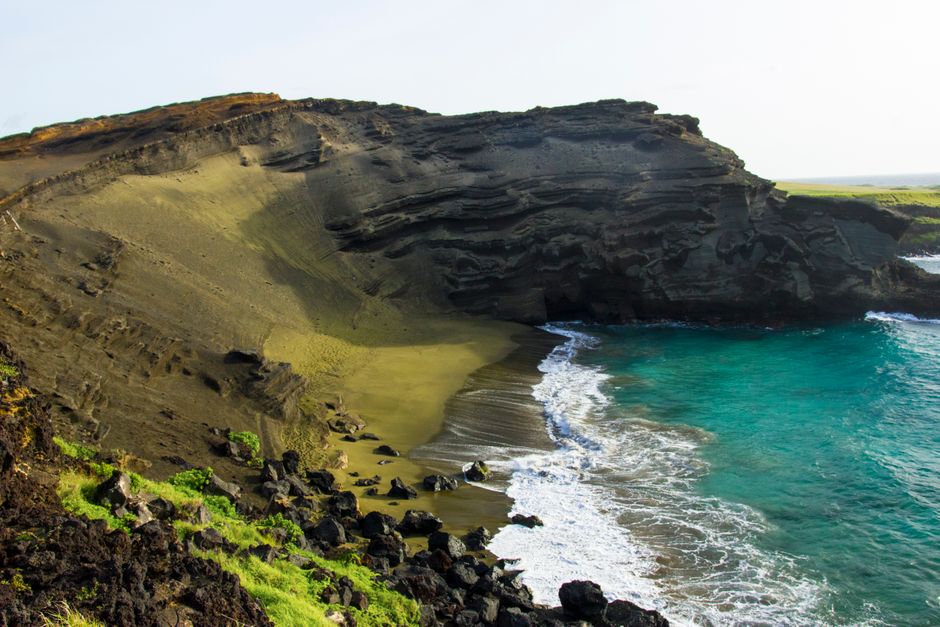
Papakolea is one of only four green sand beaches in the world, and the color comes from olivine crystals eroded from the surrounding cinder cone. The trail is a 2.5-mile one-way walk, 5 miles round trip, along a windswept coastal plain to a cove that feels like the edge of the Earth. The beach itself sits inside a collapsed cinder cone, and the olivine sand glints green in direct sunlight.
This is not a shaded stroll. The wind is relentless, the sun is brutal, and the trail is essentially a rough dirt road that local drivers navigate in trucks, offering shuttles for a cash fee. You can walk it, but you will earn the beach. Wear a hat, apply sunscreen liberally, and carry more water than you think you need. Check tide and surf conditions before descending the steep path into the cove. High surf can make the beach dangerous, and the climb back up the loose cinder is taxing even in calm conditions.
7. Akaka Falls State Park Trail (Near Hilo)
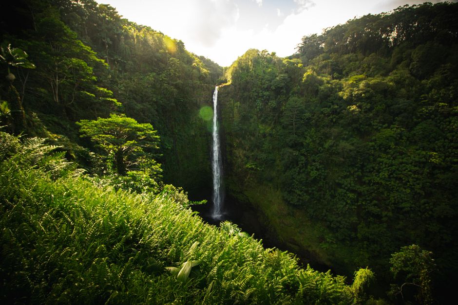
Akaka Falls is the easiest waterfall hike on the Big Island and one of the most accessible in the entire state. The trail is a 0.4-mile paved loop through a lush rainforest that leads to an overlook facing the 442-foot Akaka Falls. Along the way, you pass a secondary viewpoint for Kahūnā Falls, which is impressive in its own right. The path is stroller-friendly and suitable for all ages.
The entrance fee is $5 per car, cash only at the gate, so bring small bills. Tour buses arrive in waves starting mid-morning, so aim to get there when the gate opens to enjoy the loop without crowds. Combine this stop with a drive through the old sugar town of Honomū and a visit to the nearby ʻAkaka Falls Lookout for a relaxed half-day outing on the Hilo side.
8. Puna Trail to Haʻena Beach (Puna District)
The Puna Trail is a 2-mile one-way hike, 4 miles round trip, through ironwood forest and across old lava fields to a secluded black sand beach. It is located about 30 minutes from Hilo in Hawaiian Paradise Park, and it carries a quiet, off-the-beaten-path energy that the more famous trails lack. Visitors have reported seeing 25 to 30 sea turtles hauled out on the sand in a single visit, which makes the hot, exposed walk feel like a small price to pay.
The trail is mostly flat but offers no shade. Start early, carry water, and prepare for a beach with no lifeguards and strong currents. Swim with extreme caution, if at all. The trail passes abandoned cars and remnants of old settlements, a quirk of the Puna district’s history that adds an unexpected layer of interest. The trailhead can be tricky to find: look for the public access gate near the end of the paved road in Hawaiian Paradise Park.
9. Kiholo Bay Trail (North Kona)
The Kiholo Bay Trail follows a segment of the Ala Kahakai National Historic Trail, a coastal path that once connected Hawaiian settlements. This section is 4 miles one way, 8 miles round trip, flat, hot, and exposed. The payoff is a turquoise bay where sea turtles glide through calm water, a lava tube pool that opens to the sky, and a black sand beach framed by coconut palms. The trail passes through the edge of the Mauna Kea Resort area, which makes it one of the few resort-adjacent hikes on the island.
Start at sunrise or late afternoon to avoid the midday heat. Bring snorkel gear: the bay is shallow and protected, and the turtle encounters are reliable. There are no facilities or water sources along the trail, so pack everything you need and carry out your trash.
10. Makuala OʻOma Trail (Kohala Coast)
The Makuala OʻOma Trail is a lesser-known local favorite recommended in the r/VisitingHawaii community. It is a moderate 2-mile loop through lava fields near Waikoloa Village, with sweeping views of Mauna Kea on clear mornings and the Kohala coastline stretching north. Petroglyphs are visible along the route, carved into the lava by early Hawaiians, and the sense of solitude here is rare for a trail this accessible.
There is no shade, no water, and no facilities. The trailhead is marked, but parking is informal: a pull-off on the side of the road. Come prepared with water, sun protection, and a sense of direction, as the lava field can be disorienting in flat light. This is a hike for travelers who want a quiet, local experience away from the national park crowds.
Best Hikes Big Island Hawaii by Category: Quick Reference
If you are building your itinerary around a specific type of experience, this quick reference sorts the trails by what they do best.
For families with kids, the top picks are the Thurston Lava Tube, Devastation Trail, Akaka Falls, and the Kaulana Manu Nature Trail. These trails are short, safe, and deliver a big payoff without testing young legs or patience.
For experienced hikers looking for a challenge, the Captain Cook Monument Trail, Pololū Valley, and Kiholo Bay demand longer distances, significant elevation change, or serious heat management. These are not technically difficult in a mountaineering sense, but they punish poor preparation.
Waterfall lovers should start with Akaka Falls for the easiest access. For a more challenging and less-touristed option, the 1871 Trail on the Hilo side follows an old horse-and-buggy road through dense rainforest to a series of cascades.
If a beach at the end of the trail is your primary motivation, Papakolea Green Sand Beach, the Puna Trail to Haʻena Beach, and Kiholo Bay all deliver. Each offers a different kind of shoreline: green sand, black sand, and a turquoise bay with turtles.
For wheelchair-accessible options, Devastation Trail is the standout: fully paved, flat, and ending at a dramatic overlook. The paved section of the Crater Rim Trail near the Kilauea Visitor Center is another reliable choice.
Insider Tips for Hiking the Big Island in 2026
Start every hike before 9 AM. This is the single most impactful piece of advice in this guide. The heat on the Kona side builds fast, the parking lots at popular trailheads fill early, and the afternoon clouds that roll in on the windward side can turn a clear trail into a muddy, slippery mess. An early start solves most of these problems before they begin.
The 2026 seasonal outlook suggests a potential El Niño pattern, which historically brings drier-than-average conditions to Hawaii. That could mean more stable trail conditions, but it also increases the risk of drought stress on exposed coastal routes. Check the National Weather Service for flash flood warnings before any valley hike, even during a dry winter. Pololū and the Puna Trail are particularly vulnerable to sudden rain events that can turn stream crossings dangerous.
Parking strategy matters. For Hawaii Volcanoes National Park, enter before 8 AM to secure a spot at the Kilauea Iki Overlook. For Pololū Valley, weekdays are significantly quieter than weekends. For the Captain Cook Monument Trail, the small lot at the end of Napoʻopoʻo Road fills by 7:30 AM on busy days.
Respect the land in a way that honors local values. Pack out all trash, stay on marked trails to avoid crushing fragile lava formations and native plants, and close every conservation gate you pass through. The gate closures on trails like Kaulana Manu are not suggestions: they are the difference between a thriving native forest and one destroyed by feral animals.
Cell service is unreliable on most trails. Download offline maps via AllTrails or Google Maps before you leave your accommodation. A dead phone with no cached map turns a minor wrong turn into a stressful situation.
Frequently Asked Questions About Hiking the Big Island
What is the easiest hike on the Big Island? Devastation Trail, at 1 mile round trip, paved, and flat, is the easiest. Akaka Falls, a 0.4-mile paved loop, is a close second. Both are suitable for all ages and mobility levels.
Do I need a permit to hike in Hawaii Volcanoes National Park? No hiking permit is required for day hikes. You only need to pay the $35 per-car entrance fee, which is valid for seven consecutive days.
What is the most dangerous hike on the Big Island? The Captain Cook Monument Trail is the most physically demanding due to the steep, exposed climb back up. Pololū Valley is the most hazardous in wet conditions because the mud turns the steep trail into a slide risk.
Are there waterfall hikes on the Big Island that are safe for kids? Yes. Akaka Falls is the safest and most accessible. Avoid swimming near any waterfall due to falling rocks, strong currents, and the risk of flash flooding upstream.
Final Thoughts: Choosing the Right Hike for Your Trip
The best hike on the Big Island is the one that matches your fitness level, your time budget, and the region where you are staying. A family based in Kona will have a very different ideal trail list than a solo traveler camping near Volcano. Use this guide to build a shortlist, then check current conditions before you head out. An active volcanic island does not follow a static schedule, and trail closures or weather shifts can change your plans overnight. Bookmark this page, share it with your travel group, and pin it for your 2026 Big Island adventure. The trails are waiting.
